Below you can find a survey of all existing transporter bridges. That is, the transporter bridges which are present today. Not all of them can actually be used.
In 1881 there began the the construction of a canal between the North Sea and the Baltic. This channel needed to be suitable for large sea ships, which by this canal had the possibility of a shorter route. Shorter than the route around the entire Danish peninsula. The canal was especially important for the German navy, which was involved specially in the construction of the canal.
In first instance there were constructed 16 ferries and seven bridges. This is what happened to the main railway line between Hamburg, Flensburg and on to Denmark. For this double track railway (which was previously created) two single-track railway bridges were laid out close to each other. These bridges had a passage opening of 50 meters. Usually the bridges were open, and only if a train arrived, they were closed about 10 minutes before passage of that train. As the train had priority on shipping, it frequently happened that ships had to wait. For the ships, and especially for the German navy this was a worrying situation.
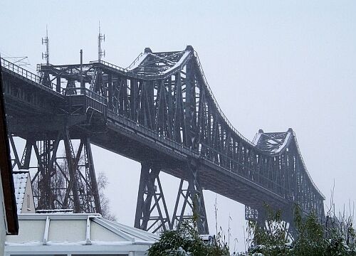
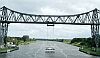
Between 1907 and 1914 the canal was widened. This was ordered by the German navy. Together with the widening of the canal the two bridges in the line should disappear. Instead, there should be built a high bridge. The Navy demanded a vertical clearance of 42 meters and a width of 120 meters. Such a bridge was technically not a problem. But another problem arised. The station was Rendsburg (say low level) was situated 600 meters away from the existing bridge. And a decline from the new bridge with a height of almost 50 meters to low level from would result in a steep slope. In order to make possible a normal inclination, the line was shifted, and an elliptical orbit of 4.5 km was constructed around the eastern city district Eider. Construction works started in 1910 and finished in 1913. The town of Rendsburg was afraid that it would be a city devided in two parts by a high earthen dam and demanded that the access road to the bridge on the north shore for about 800 meters length would not be in the form of an earthen dam, but would be constructed in the form of additional bridges. This request was granted, so we nowadays can still see these long bridges in the city.
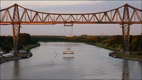
On the same moment as the construction of the elevated railway it was decided to build an transporter bridge under the bridge. On the south bank there was located the municipality of Osterrönfeld. Due to the fact that the line had to be placed higher on the bridge, in this place there was made a new railway station quite a bit to the south. People in this municipality, traveling to Rendsburg, were therefore faced with a long walk to the new railway station south of the village, and then to experience a much longer train journey. In the first place on the south side of the channel, but also on the north side where the new elliptical diversion resulted in an about 5 km longer way. The municipality demanded a ferry, a requirement as we know, has turned into an transporter bridge, hanged from the high railway bridge.
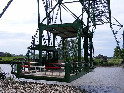
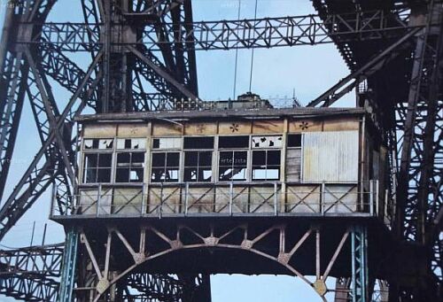
The transporter bridge was inaugurated on December 2, 1913. The platform that is at the bottom of the cable is 14 meters long and 6 meters wide. This makes it suitable for the transport of cars 4 and 60 pedestrians. The crossing by this transporter bridge is free of charge.
In summer the bridge can be visited on sunday. This is only allowed as a guided tour, in groups of up to a maximum of 14 people.
In april 2016 a collision took place between a large sea vessel and the gondola of the transporter bridge. Happily there was no personal damage, but there was heavy material damage. From that month on, the transporter bridge was out of service for a long time. Long deliberations took place to decide, but happily, they decided to rebuild the gondola. In 2024 the new gondola was opened. However, in 2025 the control system still showed so many malfunctions that the transporter bridge was taken out of service from March 2025.
| Opening | 1913 |
| Distance between shores | 135 meter |
| Total lengte | 197 meter |
| Clearance | 42 meter |
| Total height | 67 meter |
| Speed gondela | 1,24 m/sec |
| Motor power | 4 x 4,5 kW |
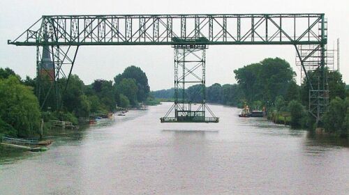
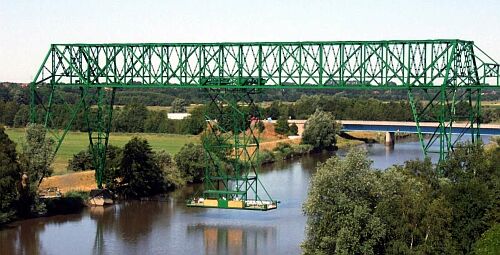
A side view on which we can see the construction of the gondola. It hangs on cables connected to a movable platform. The bridge is operated as a railway bridge. On it the train passes from Hamburg to Flensburg and further on to Denmark.
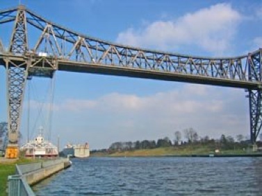
A side view with the gondola at the shore. In the background we se a large sea ship, that just has pased the bridge.
A picture of all of the bridge. The middle of the bridge is the peace that is situated above the canal, the other bridges on both side ar to bring forces of the train and wind to the other pillars.
Between the places Osten and Hemmoor in Germany there was for a long time a ferry over the river Oste. The ferry was not very reliable. As a result of the fluctuating water level in the winter and because of ice the ferry was often out of service. And also, the ferry had become too small for the increasing traffic intensity.
Around the turn of the century the community was looking for an lternative to the ferry. A bridge seemed nice, but that would have been (because of shipping) turning bridge. A movable bridge, however, would be too expensive. Because there were several transporter bridges in the world, the people in Osten had the idea of making such a one in Osten. The municipality on itself could not finance such a transporter bridge, but together with other municipalities in the area, and with the district and the county, there coulc be raised sufficient money to build an transporter bridge. When we look at the investment of 280,000 marks for a congregation of 600 residents, it was quite an severe undertaking.
In 1909, the preparations were so far that one could begin with the construction. In the same year the transporter bridge could be opened. Due to the ever increasing number of cars and correspondingly growing traffic the municipality could make a profit with the transporter bridge. However, in the '60s the number of cars was so much increased that it was decided to build a new road bridge some 200 meters westward in the new Federal Highway 495. This bridge was opened in 1974, after which the transporter bridge was closed. The transporter bridge was taken into ownership by the Kreis. A volunteer organization now provides the exploitation. The transporter bridge is classified as a technical monument. In 2001 it was remarked that the technical status of the bridge was so bad, that it had to taken out of exploitation. After an extensive restauration it has been taken into exploitation again in the year 2006.
The platform of the transporter bridge is designed for the transport of cars. The platform is not hung up by cables, but is connected via a steel construction to the upper part of the bridge. This is done in order to minimize the influence of the wind. The dimensions of the platform (after restoration in 1966) is 4.3 meters wide and 16 meters long. Until that year, the dimensions were 3.5 meters by 14 meters.
The transporter bridge is in use only in summer. In low season only in the weekends, in the summer period every day. The transporter bridge is worked once an hour (in midsummer once every half hour). Extra visits outside the normal exploitaton hours can be made on appointment.
| Opening | 1909 |
| Distance between shores | 80 meter |
| Total length | 91 meter |
| Clearance | 30 meter |
| Total height | 38 meter |
| Speed gondela | . m/sec |
| Motor power | 2 x 18 kW (until 2001) 1 x 13 kW (from 2001) |
A side view of the transporter bridge in Osten. The foto was taken from the new bridge which is situated 200 meters further. On the foto we can recognize clearly the construction of the bridge.
View to the platform of the transporter bridge. It is almost at the shore. We can see the construction on which it is connected to the bridge construction.
A side view of the transporter bridge in Osten. In the background we see the new bridge which was built in 1974.
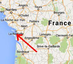
Rochefort is located at the mouth of the Charente River. Over this river there used to run a ferry to the villige of Echillais on the south shore. In the last years of the operation this was a steam ferry. A certain crossing could not be provide by this ferry. In bad weather, such as big storms, the ferry was not in exploitation. Moreover, the capacity of the ferry was too small. Replacement was necessary.
In 1897 a plan was made to build an transporter bridge. Construction began in 1898, and in July 1900 the transporter bridge was put into use. In French language it is called a "Pont Transbordeur".
The transporter bridge has been in use until 1967. In that year, a lifting bridge was built, about 250 meters west of the transporter bridge. That bridge has already been replaced by a higher and larger bridge about 150 meters further to the west. That bridge was opened in 1991. From the end of exploitation of the transporter bridge in 1967 it has for a long time been out of use. But in 1994 it was reopened as a tourist connection only for pedestrians and cyclists. Cars may no longer make use now of the transporter bridge.
On the south side of the transporter bridge there is a small museum where some explanation is given about this connection.
| Opening | 1900 |
| Distance between shores | 150 meter |
| Total length | 175 meter |
| Clearance | 50 meter |
| Total height | 66 meter |
| Speed gondola | . m/sec |
| Motor power | . kW |
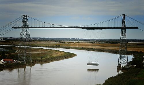
A view of the Pont Transbordeur in Rochefort. The platform is above the river. On the left there is the cityof Rochefort, on the right the village of Echillais.
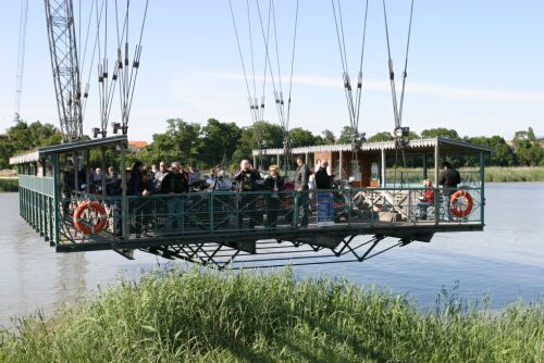
A foto of the platform. We can see clearly, that it is a broad platform. The capacity is much higher than that of a ferry.
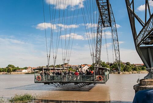
Another foto of the platform. We see clearly the hanging cables to which the platform is connected. These are not exactly vertical, in order to minimise fluctuations of the platform because of the wind.
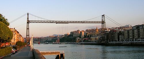
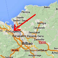
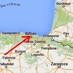
The port town Bilbao is located in Basque Country, in northern Spain. The city is not situated at the sea coast, but about 10 kilometers upstream of the river Nervion. Just as in Rotterdam, the ports of the city were in the beginning located quite close to the city. It was therefore necessary that see ships could sail up the river to this ports.
Around the harbor mouth, so about 10 km outside the city centre, on both banks of the river there were villages. A connection between these two parts of the city was highly desirable. In 1890, the concession was granted to make a transporter bridge, and three years later, in 1893, the transporter bridge was opened. It formed a connection between the Portugalete district on the left bank and Las Arenas on the right bank.
The construction of the transporter bridge consisted of two portals, between which a suspension bridge was made. In order to derive the large forces, large tension cables were connected at both ends with the structure, which end about 100 meters inland between the buildings of the city, anchored to large concrete blocks. Because the substrate to one bank is very poor (sandy soil) there had to be dug deeply to create a solid foundation. On the other side there was rocky ground, so the foundation there could be simpler. High on the suspension bridge drove a car, at which through a cable the platform was connected.
From the beginning on the transporter bridge was suitable for cars (wagons in the early years) and pedestrians. For thes pedestrians there were two divisions, first class and second class. These sections were separated from each other by a net. First class passengers could sit on covered banks on the side of the gondola. For the second class passengers there was place on the open middle space, which they had to share with packets, carts and cattle.
During the civil war in Spain that began in 1936, the building was heavily damaged. On June 17, 1937, almost at the end of the civil war, the transporter brige was blown up with explosives by the retreating northern army. This happened five days before the end of the civil war. Because the remains of the bridge hindered the shipping, these remains were quickly removed. Only two years later there was a begin to rebuild the transporter bridge and again two years later, in 1941, the transporter bridge was reopened.
Today there are 300 sailings a day. Each year there are four million of passengers and half a million cars which are transported by the transporter bridge.
| Opening | 1893 |
| Distance between shores | 151 meter |
| Total length | 161 meter |
| Clearance | 45 meter |
| Total height | 51 meter |
| Speed gondela | . m/sec |
| Motor power | . kW |
The high transporter bridge in Bilbao. To the right we can see the span cables, somewhere anchored between buildings in the city.
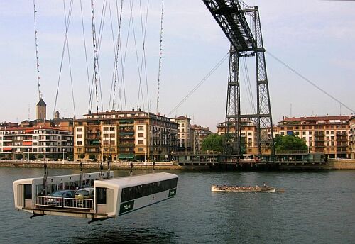
The platform of the transporter bridge. In the middle cars find a place, to the right and to the left there are covered places for passengers.
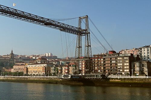
The transporter bridge with platform on the other shore of the river.
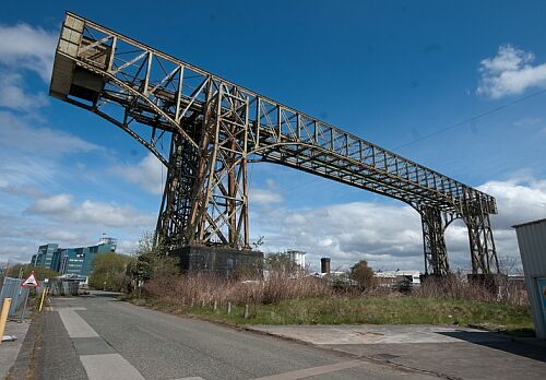
The town of Warrington is located along the Mersey River, about halfway Liverpool and Manchester. Along this river in many places there was established some industry. Southwest of the city of Warrington there was located a chemical plant by Joseph Crosfield and Son Ltd. In 1919 the company was acquired by Lever Brothers, and it is now part of the large Unilever group. Two transporter bridges were constructed for the plant in Warrington. The first in 1905, just north of the current location. Today this structure does not exist anymore. A second transporter bridge (the one still existing) was built in 1916.
From the time of building of this transporter bridge it was used for railway cars, which were transported from the chemical factory to the station on the eastern bank of the river Mersey. In 1940 it was converted for trucks (up to 18 tons). In 1953, the capacity has been increased to trucks of 30 tons. The ferry is out of service since 1964. The transporter bridge is on the list of English Heritage, but it is in a poor condition. The steel structure is affected by rust. Also, walkway on the top of the bridge is in such a bad condition that it is dangerous to use it.
The transporter bridge is listed by English Heritage, but is in poor condition. The steel structure is being affected by rust formation. The walkway above the bridge structure is also in such poor condition that it is dangerous to use it.
The construction is located on private grounds of the factory, and cannot be visited.
| Opening | 1916 |
| Distance between shores | 57 meter |
| Total length | . meter |
| Clearance | 23 meter |
| Total height | . meter |
| Speed gondela | . m/sec |
| Motor power | . kW |
A side view of the transporter bridge. The left part has been build at the reconstruction in 1953, when the transporter bridge was made available for lorries of 30 tons (in stead of 18 tons).
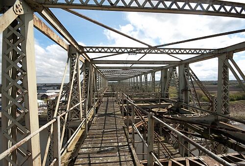
View on the upper construction. On this foto we can see clearly the bad status of it. Rust and rotting wood are clearly available.
The surroundings is clearly that of an industrial landscape. To theleft the chemical factory, to the right (behind the fence on the edge of the foto) there is a public road, but also on that side it is an industrial landscape.
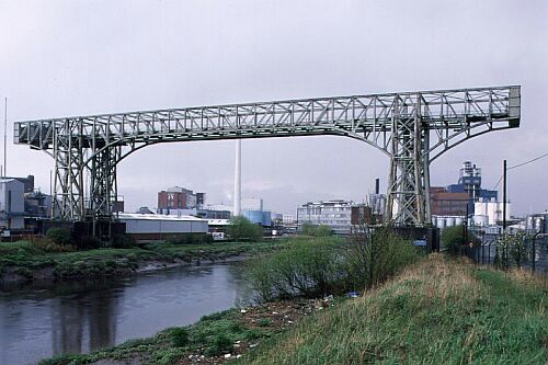
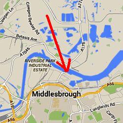
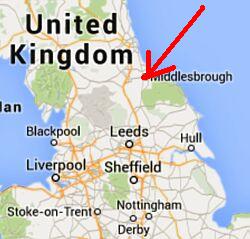
Midlesbrough is a city on the east coast of England, situated on the River Tees. The city is located about 10 km from the North Sea on the south side of the river. Seagoing vessels sailed on the river inland to an industrial estate and (in the past) continued to Stockton-on-Tees. Because of the high passage which was needed for ships in 1911 it was decided to build an transporter bridge.
Already in 1872 there were plans for an transporter bridge at this place. But only in 1910 the decision was made to construct such a construction. It was created to replace the steam ferry. Because of the seagoing ships a high clearence was required. In October 1911 the transporter bridge was ready, and could put into use with great festivities.
Despite the fact that the transporter bridge was struck by a bomb in World War One, it could be repaired quit fast. In 1985 the construction was placed on the list of English heritage.
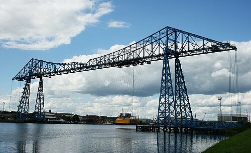
The transporter bridge is stil in use as a ferry over the river Tees. The platform has a capacity to take 200 persons and 9 passenger cars per voyage.
| Opening | 1911 |
| Distance between shores | 173 meter |
| Total length | 259 meter |
| Clearance | 49 meter |
| Total height | . meter |
| Speed gondela | . m/sec |
| Motor power | . kW |
The transporter bridge in Middlesbrough with a clear view to the platform.
The road to the platform with three lanes for passenger cars. Pedestrians will go on board at the side of the platform.
The transporter bridge seen from quite a distance. We can clearly see that a seagoing vessel can sail under it.
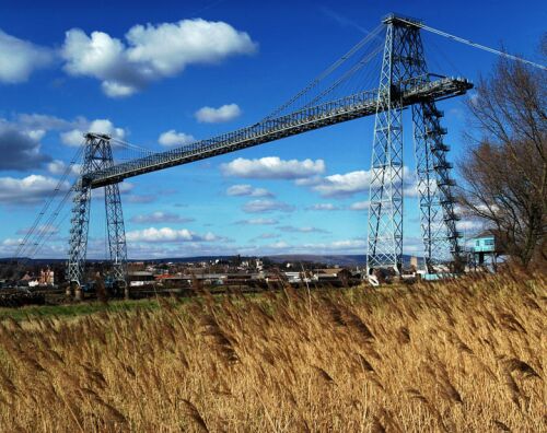
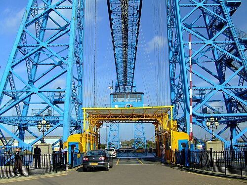
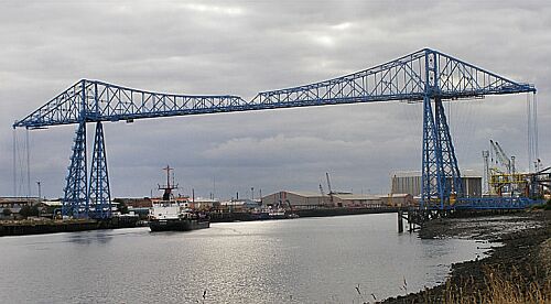
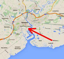
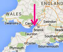
Newport is a major port city on the south of Wales, near the English border. In the midlands of Wales there are large coal mines. To export these coal it was transported to the ports where it was put on ships. Newport had, besides Cardiff, thus become a major port.
Newport is located on an estuary, an offshoot of the River Usk. Vessels can come a long way inside the land area. The port activities took place near the center ofNewport. Those ports were for the majority located on the east side of the river. The houses stood on the west side. For workers who wanted to go to work, this meant a long journey (by feet) of minimal 4 km of length. Approximately at the place of the current transporter bridge, there was a ferry. But at this location there were several problems. The tide in this place has major differences between high and low tide. It was difficult to build the ferry. Further on, there was a large flow in the river at times of the tide. Because of that, there had been several accidents with the ferry.
In 1900 it was decided that the ferry had to be replaced. It came out that a bridge was not suitable. Given the demands of the shipping industry would require a very high bridge, with correspondingly long ramps. The concept of "transporter bridge" was around that time already known, and the engineer responsible for the construction proposed to build also in Newport a transporter bridge. This was not cheap, but with about £ 100,000 it was still much cheaper than a real bridge. The approval to build an transporter bridge came in 1900, and after some preparation the work could start in 1902. The construction was finished in 1906, so on 12 September of the same year the transporter bridge could be taken into use.
The width of the water was about 180 meters on that spot, so that one could suffice with a bridge with a total length of 197 meters. The height of the transporter bridge was selected such that at high tide there is still 54 meters available for the passing ocean-going vessels. By that it was the highest and longest aerial of Europe. Two electric motors of 35 hp each were used for propulsion.
In 1985, the transporter bridge has been stopped because of dilapidation. Fortunately, after thorough restoration in 1995 it was reopened. Nowadays we can visit the transporter bridge. On the west bank of the river there is a visitor center where some information is given about the bridge. One can climb the construction by stairs (270 steps).
| Opening | 1906 |
| Distance between shores | 180 meter |
| Total length | 197 meter |
| Clearance | 54 meter |
| Diameter cable | 7,5 cm |
| Speed gondela | 3 m/sec |
| Motor power | 2 x 35 pk |
A side view, where we can see clearly the platform. Two double pillers, between which is placed the construcion of the horizontal part. With span calbes it is kept on its place. At both ends there are span cables to the anchors, some 100 meters further anchored in large blocks.
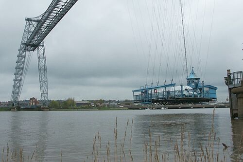
The platform of the transporter bridge. We se some cars. The cables are slantwie. By this it is prevented that the platform will swing too mucht because of the wind.
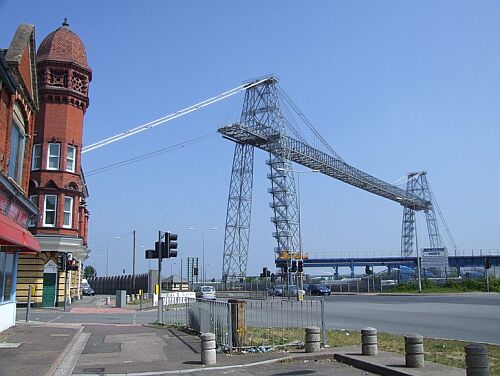
View to the transporter bridge seen from the city. We see clearly the span cables to keep the construction upright. The go some distance inside the city where they are anchored in large blocks.
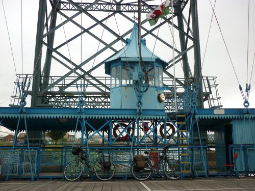
Two bicycles during the ferry ride. The bicycles are very tiny in relation to the construction of the transporter bridge.
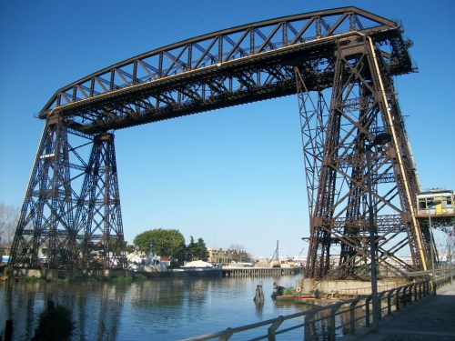
Rio de Janeiro is the capital of Argentina in South America. The city is situated on the sea coast, and on the south of the city the Riachuelo river flows from the inland to the sea. On this south side of the river in the nineteenth centyry there were made extensive residential areas. These had to be connected to the center of the city.
The construction of the transporter bridge started in 1908. Permit for the construction was given to the railway company, although the cost of ferry was worn by the province. The transporter bridge was in use taken n 1914.
In 1914, the transporter bridge inaugurated. The bridge is named "Puente Transbordador Nicolás Avellaneda". This was a president of Argentina who lived from 1837 to 1885. He was president between 1874 and 1880. The name of this president is also connected to the district of Avellaneda, located south of the river.
The transporter bridge remained in use until 1960. Already in 1940 some 100 meters away from the transporter bridge, there was opened a lifting bridge, but the transporter bridge remained in use until 1960. It can not be used nowadays. There are plans to designate the transporter bridge as an industrial monument.
The platform of the bridge measures 8 by 12 meters, and could carry, besides pedestrians and cars also tramscars.
| Opening | 1914 |
| Distance between shores | 65 meter |
| Total length | 108 meter |
| Clearance | . meter |
| Motor power | . |
The transporter bridge of Buenos Aires. The platform is connected with a steel construction to the top. We can see the platform at the most right pillar of the bridge. It hangs between the two legs of this right pillar.
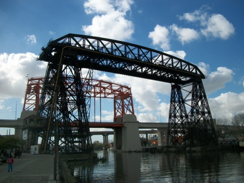
he transporter bridge and the nearby lifting bridge.
The machine room of the transporter bridge. It is a large one. Unfortunately it is in a severely bad state.
This page is part of the Websites of Wim Kusee
 Nederlandse tekst